 Square
DP Remarks, Reservations and Road Widening: What to Check Before Designing Your Plot
Looking for the Kalyan DP plan, an MMRDA map or a PDF download? Start with the official documents below. Then check which plan actually covers your village and survey number. A coloured map can help you locate a question; it cannot, on its own, tell you how much of a plot you can build on.
Kalyan DP plan maps & PDFs: choose the right document.
There is no single file here that should be treated as the plan for every property with a Kalyan address. The links below point to documents hosted by MMRDA for the 27-village notified area and Kalyan Growth Centre, not the whole KDMC municipal area. Confirm your parcel's jurisdiction before using a sheet.
Official files open in a new tab. Some maps are JPG images, not PDFs. Sizes are approximate; large sheets are best opened on Wi-Fi. Downloads are not gated behind our enquiry form.
27-village DP: sanctioned combined map
Listed in MMRDA's catalogue under the 11 March 2015 sanction/publication group. Read the sheet's notes and subsequent notifications alongside it; this is not a current plot-specific certificate.
Open official combined map (JPG, new tab)Excluded Part (EP): combined map
A separate sheet in the official catalogue. An EP label is a reference to investigate with the related notices and later decisions—not proof that land is unreserved or freely developable.
Open official EP map (JPG, new tab)Kalyan Growth Centre boundary map
Use this with the SPA notification to investigate whether a parcel falls within the Growth Centre area. A village name alone does not confirm inclusion, especially where only part of a village is covered.
Open official boundary map (JPG, new tab)Growth Centre SPA notification · 30 April 2016
The notification behind MMRDA's appointment for the specified Growth Centre area. It is a jurisdiction document, not a land-use map or an approval for an individual building.
Open official notification PDF (new tab)Need a detailed map sheet or the large plan PDF?
Use the combined map's key map to identify the relevant sheet first. The official catalogue separates the sanctioned map set from the Excluded Part set; the same sheet number can appear in both.
Sanctioned map set
Excluded Part map set
Open detailed sheet 10.1M · PDF, approximately 87 MB (new tab) ↗. This single-sheet drawing was visually checked for this guide; its title block refers to the 27-village plan and 2017 Excluded Part sanction. It is not the entire KDMC DP and is not evidence that no later change applies.
Open MMRDA's full official catalogue ↗ and select Details of Project for notices, map sets and regulations; select Present Status for the authority's published position. If a direct file moves, return to this catalogue. Map files are linked, not mirrored or embedded.
Need a municipal KDMC DP, rather than the 27-village plan?
Ask KDMC's Town Planning department for the applicable municipal sheet and plot-specific record. For a property in Thane city, investigate the TMC route instead. Do not substitute a nearby MMRDA sheet simply because it appears in a search for “Kalyan DP plan PDF”.
For orientation only, the independent KDMC-area map viewer ↗ offers a third-party overlay. It is not a certified authority record; access conditions and alignment can differ.
Found the map, but not the answer for your plot?
Share the village, survey / CTS reference and your planning concern in the existing enquiry form. We will discuss what needs checking and the scope of any further professional work.
Calling? Mention the Square Space website. Do not send private title documents through the initial form.
First make the references agree.
“Thane” can mean the city, district or a much wider property-search area. “Kalyan” in an address does not identify every planning boundary. Start with the village / ward, survey, Gat or CTS reference, subdivision and the actual parcel location. Do not choose an authority solely from the postal city.
Which villages are named in the Growth Centre appointment?
The MMRDA overview names Bhopar (part), Sandap, Usarghar (part), Gharivali (part), Mangaon (part), Hedutane (part), Kole, Katai (part), Nilaje (part) and Ghesar (part). This list is not a parcel-level jurisdiction check. Read the official notification and boundary map, including any subsequent changes.
Ask which development or regional plan applies and which authority can provide the relevant record. The Directorate of Town Planning's General FAQ distinguishes the Development Plan and Regional Plan routes for zone certificates. One office or portal does not serve every plot.
- 01
Locate the parcel
Village + survey / Gat / CTS + subdivision.
- 02
Confirm the authority
Check the boundary, not just the postal address.
- 03
Match the records
Sheet, legend, sanction and later changes.
- 04
Review the proposal
Relate confirmed records to a measured site and intended use.
Original explanatory diagram. This is a preparation sequence, not an official approval process.
Three map questions that are easy to confuse.
Zone / land use
What use category is indicated for the identified land? A residential or commercial colour is not a sanction for your proposed building.
Reservation / designation
Is land identified for a public purpose or another plan provision? A colour alone does not settle legal rights, acquisition, compensation or a release route.
Road alignment / widening line
Is there a road provision affecting the site? A visible road edge or screenshot measurement is not a verified boundary, final building line or setback.
Read the legend on that exact sheet. Do not transfer the colour key from a simplified promotional map, an older sheet or a different authority. Inspect line styles, road-width labels, reservation references, village boundaries and the title block together. Absence of a readable label in a low-resolution image does not establish absence of a restriction.
Use an online overlay to orient yourself, not to measure a legal boundary. Satellite alignment, missing subdivisions and image resolution can make a line look clear when its relationship to the parcel is still uncertain.
Ask what the map is—and when it applies.
Record the title, issuing body, sheet number, scale, notification reference, date, legend and stated status. A draft proposal, sanctioned plan, Excluded Part sheet, later modification and informal online overlay are different records.
- Match the parcel and subdivision—not just a nearby landmark.
- Identify whether you have the combined overview or a detailed sheet such as 10.1M.
- Read sanction notes and modification references, not just the year in the heading.
- Ask what subsequent notifications or authority records affect the property.
- Check whether a certified part plan, zone certificate or plot-specific DP remark is needed for the question.
The official MMRDA overview describes partial sanction in March 2015 and later Excluded Part decisions in 2017. That history does not establish the current status of every parcel. Likewise, a file stored in a “2021-10” website folder is not necessarily a plan sanctioned in October 2021.
A general article cannot determine the operative position for an individual site. Do not assume an older provision has disappeared because a newer draft can be downloaded, or assume a planning-horizon year proves that a sheet is the latest record.
If a line crosses the site, do not jump to an FSI calculation.
First establish that the line has been located against the correct parcel and read from the correct authority record. Then relate it to a suitable measured survey and investigate access, circulation, building arrangement and the inputs needed for further design.
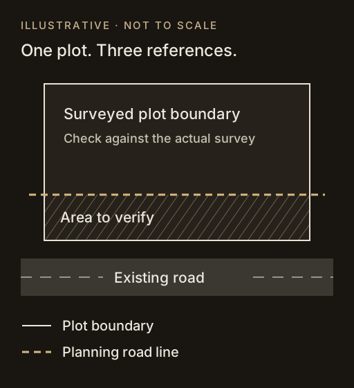
- Verify the geometry. Identify the survey reference, boundary and the meaning of the road line; do not scale a WhatsApp screenshot.
- Verify the record. Ask for the applicable road width, alignment, remark and any relevant amendment from the responsible authority.
- Review the consequences. Assess the proposed use, entry arrangement and design constraints before settling a layout.
Legal questions about reservation, title, acquisition, objections or compensation require appropriate independent advice. This page does not promise a reservation can be removed, a road alignment changed, or any FSI / TDR entitlement. Where the question is an entrance onto a controlled road, use the road-access NOC guide: access permission and a DP road provision are not the same thing.
Bring a small decision register, not a guessed layout.
- Property identity: village / ward, taluka, survey / Gat / CTS number and subdivision.
- Location: locality and a clear description or map reference; an address alone may not locate the parcel.
- Your concern: road widening, reservation, zone, unclear authority or conflicting records.
- Source details: map title, sheet, date and notification / remark reference, if available.
- Intended use: what you want to build and whether you are buying, planning or reviewing an existing property.
What can I write in the contact form?
“I found Square Space through your DP remarks guide. My property is in [village / locality], [taluka], survey / CTS [reference]. I am planning [intended use]. I have a question about [road line / reservation / zoning] on [sheet or remark reference, if known]. Please call me to discuss a site-specific review and its scope.”
You do not need to know every answer before speaking to us. Mark unknown information as unknown. Start with a description in the form; private title documents and sensitive records can be discussed through an appropriate channel if an appointment proceeds. This example is not a statutory DP-remark application and does not replace an authority's prescribed form or document list.
Discuss the plot before committing to a scheme.
Square Space provides architectural and engineering consultancy, structured planning, and assistance with building permissions and NOCs. For a DP-related enquiry, we can discuss the parcel, intended use, available records and the next professional or authority inputs needed.
The first conversation
Explain what you have found and the decision you are trying to make. We discuss whether a further assessment is appropriate.
An agreed professional scope
If you appoint us, deliverables, document requirements, fees and responsibilities are agreed before work proceeds. No permission or development entitlement is guaranteed.
Explore land and site-feasibility consultancy, structured planning and our service context for Kalyan or Thane. Square Space is an independent practice, not KDMC, MMRDA or a government map-issuing portal.
Common Kalyan DP plan questions.
Where can I download the Kalyan DP plan PDF?
Start with the official map and PDF links at the top of this guide. They cover MMRDA's 27-village notified area / Growth Centre references, not every KDMC property. Many official sheets are JPG files. A detailed 10.1M PDF is also linked and is approximately 87 MB. Confirm the correct authority and sheet before downloading.
Are the KDMC DP and MMRDA Kalyan Growth Centre plan the same?
No. Do not treat those labels as interchangeable. The Growth Centre has a specified boundary and authority appointment within the wider planning history of the 27 villages. Establish where the actual parcel falls and which authority record applies.
Can I use a map screenshot as my official DP remark?
No. A screenshot or third-party overlay is an orientation aid, not a certified plot-specific authority record. Ask the responsible authority or appointed professional what remark, zone certificate or part plan is appropriate for your purpose.
Does a road line mean I cannot build on my land?
A general map cannot answer that. Verify the plot boundary, relevant line, authority record and measured site information, then obtain advice on the proposal and any legal questions. Do not infer an approved setback, acquisition area or building entitlement from the colour alone.
Can Square Space issue the official DP remark or guarantee approval?
Official records and permissions come from the responsible authority. Square Space can discuss consultancy and assistance within an agreed scope. We do not guarantee approvals, reservation release, compensation or a particular development potential.
Sources & scope.
- MMRDA — Proposed Growth Centre in Kalyan Taluka: Overview, Details of Project and Present Status tabs (new tab)
- Government notification dated 30 April 2016 — MMRDA-hosted PDF (new tab)
- Directorate of Town Planning and Valuation — planning / regional-plan / general FAQs
- Official MRTP Act reprint — text dated 10 March 2025; check subsequent amendments
Sources checked 20 October 2026. Official files remain on the issuing body's website; availability and records can change. The municipal KDMC download portal could not be reliably accessed during this review, so no unverified municipal PDF is presented as the correct plan. This guide is not a certified DP remark, measured survey, legal opinion or statement of development entitlement. Illustrations explain the questions only; they do not show a real affected property.
Understand the line before designing around it.
Tell us where the property is, what you intend to build and which map or remark has raised a question. Request a callback from Square Space to discuss your requirements and the appropriate next step.
Please mention the Square Space website when calling. Further professional work, if appropriate, is subject to an agreed scope and fees.